
Trek Duration: 6–7 Days
Maximum Altitude: 15,485 ft (4,694 m)
Difficulty Level: Moderate to Difficult
Best Time to Visit: May to June and September to October
Location: Gangotri, Uttarkashi District, Uttarakhand, India
Why Choose the Kedartal Trek?
The Kedartal Trek is one of the most stunning high-altitude lake treks in the Indian Himalayas. Unlike more commercial routes, this trail offers raw beauty, solitude, and a deep connection with nature.
Key Highlights
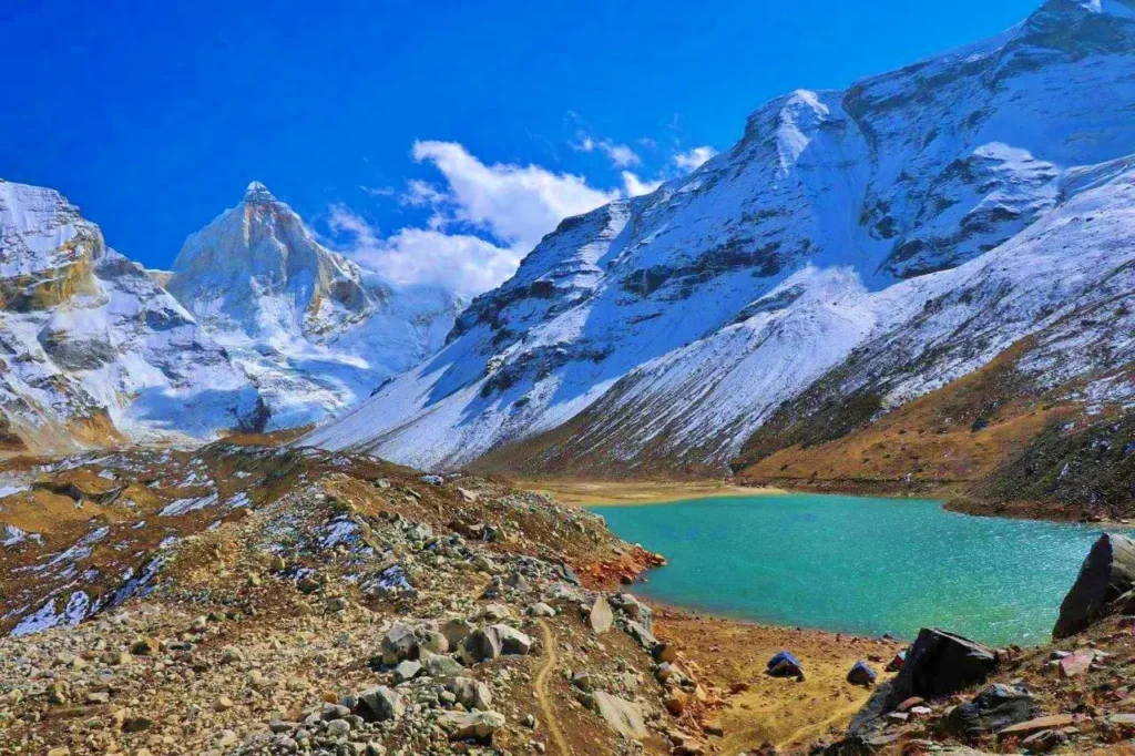
- Crystal-clear Kedartal (Shiva’s Lake) at the base of the mighty Thalay Sagar
- Panoramic views of Meru, Bhrigupanth, Jogin peaks, and more
- Challenging terrain for those seeking a rewarding adventure
- Less crowded trail, ideal for experienced trekkers
Kedartal Trek Itinerary Overview
Starting Point: Gangotri (accessed via Dehradun or Rishikesh)
| Day | Route | Elevation |
|---|---|---|
| 1 | Dehradun to Gangotri (drive) | 10,055 ft |
| 2 | Acclimatization at Gangotri | – |
| 3 | Gangotri to Bhoj Kharak (trek) | 12,440 ft |
| 4 | Bhoj Kharak to Kedar Kharak | 14,200 ft |
| 5 | Kedar Kharak to Kedartal & return | 15,485 ft |
| 6 | Return to Gangotri | – |
| 7 | Drive back to Dehradun | – |
Trail Description
Gangotri to Bhoj Kharak
The trail begins with a moderate ascent through birch forests, known as “Bhojpatra.” The route is narrow and exposed in places, offering early glimpses of snow-clad peaks.
Bhoj Kharak to Kedar Kharak
A scenic stretch through alpine meadows and rocky ridges. Expect open landscapes with clear views of surrounding mountains.
Kedar Kharak to Kedartal
This is the most challenging part of the trek. The steep climb through moraines and loose rock culminates in the breathtaking view of Kedartal – a glacial lake surrounded by towering Himalayan peaks.
Camping and Terrain
- Campsites are located in raw alpine zones with minimal facilities.
- Terrain varies from forested sections to rocky ridgelines and moraine fields.
- Water is available from glacial streams; purification is recommended.
Note: This is a sensitive high-altitude ecosystem. Carry back all waste and leave no trace.
Trekking Essentials
Required Gear:
- Waterproof trekking shoes
- Down jacket and thermal wear
- Sleeping bag (suitable for -10°C)
- Trekking poles and headlamp
- Rain gear, first aid kit, water purification tablets
Documents:
- Valid government ID
- Forest permit (obtainable in Gangotri)
- Medical certificate and fitness declaration (required by most trek organizers)
Safety and Acclimatization
- Acclimatization is crucial due to the elevation gain.
- Drink plenty of water and follow a slow, steady pace.
- Be aware of symptoms of AMS (Acute Mountain Sickness).
Hiring a local guide or joining a certified trekking group is strongly recommended for safety.
How to Reach the Kedartal Trek Base
Nearest Airport: Jolly Grant Airport, Dehradun (approx. 270 km from Gangotri)
Railhead: Dehradun or Haridwar
Road Route: Dehradun – Uttarkashi – Gangotri
Public Transport: Buses and shared taxis available from Dehradun and Rishikesh
Ideal For
- Trekkers with prior high-altitude experience
- Nature lovers and photographers
- Adventurers seeking remote, less-traveled routes
Not recommended for beginners or those with altitude sensitivity.
Final Thoughts
Kedartal is not just a trek—it’s a journey into the heart of the Himalayas. With its dramatic landscapes, sacred origins, and minimal footfall, it offers an unparalleled experience for those ready to take on the challenge.
If you’re seeking a remote, soul-stirring, and physically rewarding trek in Uttarakhand, Kedartal should be high on your list.